Mesozoic stratigraphy and tectonic evolution of the Southern Alps in Slovenia
Principal Investigator at ZRC SAZU
Asst. prof. Špela Goričan, PhD-
Original Title
Mesozoic stratigraphy and tectonic evolution of the Southern Alps in Slovenia
Project Team
Irena Debeljak, PhD, Asst. prof. Špela Goričan, PhD, Prof. Aleksander Horvat, PhD, Asst. prof. Adrijan Košir, PhD, Tomaž Verbič, PhD-
ARIS Project ID
J1-1714
-
Duration
1 July 2019–30 June 2023 -
Link to SICRIS
17786 -
Financial Source
ARRS

The study area in NW Slovenia is part of a more than 300 km long transition zone between the Dinarides and the Southern Alps that extends from the Dolomites in northern Italy to Mt. Medvednica in northern Croatia. This central segment of the transition zone is crucial to understand the interference tectonics caused by overlap of two orogenic belts. The area is relatively well known stratigraphically but remains structurally largely unexplored. Stratigraphic research revealed a complex Mesozoic paleotopography of a fault-bounded submarine high (the Julian High) surrounded by deeper basins. The existing tectonic maps, on the other hand, are extremely generalized, do not reflect the determined pre-orogenic paleotopography and do not provide a clear separation of Dinaric and South-Alpine structures.
In the proposed project we will concentrate on geological and structural mapping in the Julian Alps and the Southern Karavanke Mountains. The aim of the project is 1) to summarize the relevant data on Lower Triassic to end-Cretaceous stratigraphy, 2) to present structural evidence for the existence of several superposed nappes that were emplaced during the Dinaric thrusting phase, and 3) to investigate the style and pattern of younger structures.
Specific questions that will be addressed are the following:
1) What was the configuration of the Mesozoic Adriatic continental margin preserved in the study area? What was the size and what is the likely 3D reconstruction of the Julian High?
2) What is the most probable nappe-pile restoration after the Dinaric (post-Maastrichtian) thrusting event? What was the sense of movement and what are the age constraints for this event?
3) How and when did the second, i.e. South-Alpine phase of shortening modify the initial nappe stack? What was the maximum stress direction and to which extent was this deformation controlled by the dextral transpressional shear? Which pre-existing structures or stratigraphic non-homogeneities were the predominant zones of weakness? Is it possible to interpret the overall dish-like shape of the Julian Alps as a South-Alpine pop-up structure?
4) How was the pattern of subsequent (Miocene) normal faults related to the contraction features of the preceding phase and what was the main cause of extension?
The final goal of the project is to construct an up-to-date tectonic map of the area and to restore the polyphase deformation history through the Paleogene and early Neogene. The data will be interpreted in a regional framework of the Alpine-Dinaric-Carpathian orogenic system and will contribute to further development of paleogeographic and tectonic models on a regional scale.
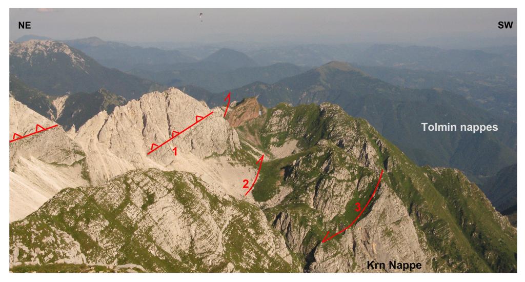
Jezero v Lužnici – Rdeči rob. Panoramic view showing 3 phases of deformation: 1= Dinaric thrust (Schlern Formation on top of the Dachstein limestone); 2 = steep reverse fault of the South-Alpine phase; 3 = younger normal fault.
Goričan, Š., Horvat, A., Kukoč, D. & Verbič, T. 2022. Stratigraphy and structure of the Julian Alps in NW Slovenia / Stratigrafija in struktura Julijskih Alp v severozahodni Sloveniji. Folia biologica et geologica 63 (2): 61–83. https://doi.org/10.3986/fbg0098